The
Highland Township Historical Society |
|---|
BACK TO ORIGINAL HIGHLAND LAND PURCHASES
A Short Tutorial On The Public Land Survey System
Presented below are a series of "Frequently Asked Questions" related to the Public Land Survey System, land patents, survey terms, etc. which should prove helpful in understanding the data presented in the Original Highland Land Purchases page. For additional information, visit the Bureau of Land Management - General Land Office FAQ page at http://www.glorecords.blm.gov/FAQ.asp
What
Is A "Township"?
What Is A
"Section"?
How Are Sections Subdivided?
What Is A
"Fractional Section?"
How Are Township
Sections Numbered?
Why Was Section 16
"Special"?
What Is A "Patent"?
How Did One Obtain A Patent?
What Is Bounty Land?
What Is A
"Pre-emption Patent"?
A township is the basic unit of area in the Public Land Survey System, consisting of a square of land, nominally six miles on each side, containing 36 sections. Townships are usually identified as being north or south of some east-west "baseline" and east or west of some north-south "meridian." Highland Township, for example, is described as "Township 3 North, Range 7 East," meaning it is in the third tier of townships north of the Michigan Baseline and in the seventh range east of the Michigan Meridian.
As a general matter, a section is defined as a square, one mile on each side, thus containing one square mile or 640 acres of land. See, however, the discussion of "Fractional Sections" below.
Sections are typically divided into "quarters," i.e., the NE, NW, SE and SW quarters. Each is one-half mile square and so contains 160 acres. Such quarters can, in turn, be further subdivided further into (i) "halves" (i.e., the E 1/2, W 1/2 or N 1/2 and S 1/2), forming a rectangle one-quarter mile wide and one-half mile long, containing 80 acres, or (ii) "quarters" or "corners" forming a square one-quarter mile on each side, containing 40 acres. Thus, for example, in the description "SE 1/4 of the NW 1/4 of Section X," the first "1/4" designates a 40 acre square located in the southeast "corner" of the larger, 160 acre "quarter" in the northwest part of the section.
What is A "Fractional Section"?
While the concept of subdividing land into square townships and sections sounds good in theory, it is impossible to map a perfectly square surface on a spherical globe such as the earth. The north/south lines slowly converge as they approach the North Pole, which in turn causes the east/west lines to shorten in length. To compensate for the earth's curvature, as well as any errors made during the original survey, the 11 sections at the north and west of a township (1-7, 18, 19, 30 and 31) are designated as "fractional sections" since they are not perfect squares and usually contain less than 640 acres. Such "fractional sections" are, in turn, subdivided into two "regular" and two "fractional" quarters. In fractional sections along the north township line (1 through 6), the NE and NW quarters are likewise "fractional" while the SE and SW quarters are regular. In fractional sections along the west township line (7, 18, 19, 31 and 31), the NW and SW quarters are "fractional" while the NE and SE quarters are regular. Any further subdivision of irregular quarter sections are typically referred to as "parts."
The term "fractional section" is also used for those which are not perfect squares because they border a large lake, bay, etc. There are, however, no "fractional" sections of this type within Highland Township.
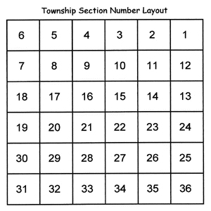
How Are Township Sections Numbered?
Sections are numbered 1 through 36. As seen in the illustration below, the northern-most tier of sections is numbered 1 through 6 running east to west. The next row of sections is then numbered 7 through 12, running west to east. This pattern continues until reaching section 36 in the southeast corner of the township.
Under the Land Ordinance of 1785, Section 16 of each township was reserved for educational uses. Upon its admission to the union in 1837, control (although not ownership) of Section 16 lands was transferred to the State of Michigan. Within months the state legislature enacted a law authorizing the sale of all Section 16 lands at auction, with the proceeds to be invested and any income used for educational purposes. The minimum bid was set at $8.00 per acre, with one-fourth due immediately and the balance payable over time at 7 percent interest. At first sales were brisk, but within a few years as many as one-third of the purchasers had defaulted. Although the legislature amended the law to lower the minimum bid, grant more favorable terms and even renegotiate previous contracts, the sale of Section 16 lands lagged until the period 1850-54, when improvements in the general economy and an increased scarcity of public lands prompted a revival, See: John M. Gregory, Superintendent of Public Education, The School Laws Of Michigan, Lansing (1859), pp. 2-14. Not coincidentally, this is the period when most of the Section 16 land in Highland Township was sold. Note that the Bureau of Land Management - General Land Office web site has no records relating to the purchase of Section 16 lands since they were sold through the State of Michigan.
A "patent," "land patent" or "land grant" is a document that evidences the transfer of ownership of land from the United States government to the person or persons named in the patent.
At the time settlement of Highland Township began, the sale of public land was governed by the Land Act of 1820 (ch. 51, 3 Stat. 566, April 24, 1820). It is often called the "Cash Act" since it eliminated the previous practice of selling land on credit. Instead, parcels were sold at a set price of $1.25 per acre, payable in full at the time of purchase. Since $1.25 was roughly equivalent to ten shillings in British coin (which still circulated in Michigan due to its proximity to British Canada), this law is also called the "10 Shilling Act" in many old Michigan histories.
To obtain a patent, the settler would travel to the Detroit Land Office and fill out "entry" papers, indicating the parcel(s) he wished to purchase. The Land Office "registrar" (clerk) would check the local office's records to make certain the claimed land was still available, while the "receiver" or bursar accepted and recorded the buyer's payment. A separate file was kept for each entry, along with two indices: (i) the tract book, with written descriptions of each entry on sheets arranged by township; and (ii) a township plat or map showing all the claimed parcels. Following its own review, the Detroit Land Office would then transmit the required paperwork to the General Land Office in Washington, D.C. where the availability of the parcel, accuracy of its description and adequacy of payment were confirmed. If all were in order, the General Land Office would then issue the actual patent.
What Is The Difference Between The "Purchase" Or "Entry" Date And Patent Date?
The "purchase" or "entry" date is the date the settler visited the Detroit Land Office, filled out the necessary paper work, and tendered the purchase price. For the most part, the dates found in the Oakland County Genealogical Society's First Land Owners Of Oakland County are "purchase" or "entry" dates. As noted above, however, the Detroit Land Office itself did not issue patents. Instead, it transmitted the required paperwork to the General Land Office in Washington, D.C. Due to delays in receiving the documentation, as well as the volume of work it handled, the General Land Office would usually take several months, and in some cases several years, before issuing an actual patent. It further appears that purchases within a particular township would be processed in "batches." Note, for example, the nine (9) patents all issued on April 1, 1837, even though the underlying purchases were made on March 30, July 2 and July 17, 1835.
As a general rule, "purchase" or "entry" dates are of most interest since they more closely correspond to the date of actual settlement. For the sake of completeness, however, dates of actual patent issuance are also included.
Starting in 1788, Congress passed a series of acts rewarding veterans for their service with grants of land. To make a claim under such acts, the veteran (or his widow, if deceased) would fill out a sworn application detailing his service. Many applications included affidavits by family members and fellow veterans, copies of family Bible records and other proof of identity, dates of enlistment and discharge, etc. If the application was approved, the veteran would be sent a "warrant" or certificate that could be presented to a local land office as substitute payment.
The earliest laws limited the veteran's choice of land to particular territories. Michigan was excluded due to an erroneous, early report which claimed most of the land to be uninhabitable swamp! As a result, bounty land played no significant role in the state's early settlement. By 1855, however, these restrictions had been removed. Surviving veterans of the Revolution and War of 1812 were thus able to use their warrants to purchase lands in Michigan. Typically, however, the veteran already had a farm and was too old to pull up stakes and settle elsewhere. As a result, a lively (and in many ways "shady") market emerged whereby warrants were sold, traded or otherwise "assigned" to others; often at a deep discount to the value of the land they could be used to buy. In Highland, for example, William Beckley used warrants originally issued to four different veterans to purchase lands in Sections 11 and 12.
What Is A "Pre-emption" Patent?
"Pre-emption" was a tactful way of saying
"squatter." In other words, the settler was physically on the property
before the parcel was officially sold. In such cases the settler was often given a
pre-emptive right (i.e., "first dibs") to acquire the land. Much of the
Section 16 (school) land in Highland was sold via pre-emption patents.