The
Highland Township Historical Society |
|---|
References To Highland Township In Early Gazetteers,
Postal Guides, Atlases And Similar Sources
Arranged Chronologically
Blois, Gazetter of the State of Michigan (1839)
Haskel and Smith, A Complete Descriptive And Statistical Gazetteer Of The United States (1843)
Bowen, United States Post-Office Guide (1851)
Fanning's Illustrated Gazetteer of the United States (1853)
Baldwin and Thomas, A New And Complete Gazetteer Of The United States (1854)
Leech, Post Offices In The United States (1855)
A Gazetteer Of The World or Dictionary Of Geographical Knowledge (1856)
State of Michigan Gazetteer & Business Directory (1856)
Leech, List Of Post Offices In The United States (1859)
Clark, Michigan State Gazetteer And Business Directory (1863)
Michigan State Gazetteer And Business Directory (1867)
Government Printing Office, Post Office Directory (1870)
F.W. Beers & Co, Atlas Of Oakland County, Michigan (1872)
R. L. Polk & Co, Michigan State Gazetteer And Buisness Directory (1875)
ABC Pathfinder: Shipping And Mailing Guide (1892)
John Clark Ridpath, Editor, The Standard American Encyclopedia ((1897)
Lippencott's New Gazetteer (1916)
King's Official Route Guide: Automobile Routes In Michigan and Northern Indiana (1920)
![]()
Page 300
Highland township, Oakland County, is composed of township three north, of range seven east. Here is a body of chestnut timber passing through a part of the township. This township contains a post office by the same name. Population, 440.
Page 363
Society lakes,(thus named from their proximity,) are several little lakes, in the vicinity of each other, no one of which exceeds perhaps 50 acres in extent, lying in Highland township, Oakland county, south-west of White lake.
Page 381
White Lake, a body of water lying on the boundary line between a township of the same name and Highland township. Its waters are drained into the Shiawassee river. Here, and around the lake, and the dividing ridge, the lands are covered with forests of chestnut timber.
NOTE: The notion that White Lake drained north into Buckhorn Creek or some other tributary of the Shiawassee River was common in early accounts and maps of Highland Township.
![]()
Daniel Haskel and J. Calvin Smith, A
Complete Descriptive And Statistical Gazetteer Of The United States, Sherman
& Smith, New York (1843)
p. 277
HIGHLAND, p-t., Oakland co., Mich., 45 N.W. Detroit, 569 W. It has 3 sch. 100 scholars. Pop 566.
NOTE: "p-t." = post town. It was also common in the early years of the republic for cities and towns to be described in terms of their distance from Washington, D.C.; in this case 569 miles.
![]()
Eli Bowen, The United States Post-Office Guide, D. Appleton and Company, New York (1851)
p. 137
LIST OF POST-OFFICES -- MICHIGAN
[With Name of Postmaster And Mail Routes]
Highland, Oakland, Rachel C. Perry, 3748, 3816
pp. 276, 278
LIST OF MAIL ROUTES -- MICHIGAN
3748. From Pontiac at 6 a.m. Tuesday, Thursday, and Saturday, by Waterford Centre, Commerce, Milford, Highland, Hartland, and Oceola Centre, to Howell, by 9 p.m. -- 41 miles and back between 6 a.m. and 9 p.m., Monday, Wednesday and Friday.
3816. From Grand Blanc, at 6 a.m., Friday, by Holly, Rose, White Lake and Highland, to Kensington, by 6 p.m., 35 miles, and back between 6 a.m. and 6 p.m. next day.
![]()
Fanning's Illustrated Gazetteer of
the United States,
Phelps, Fanning & Co., New York (1853)
p. 156
HIGHLAND, p.t., Oakland co., Mich., 45 ms. n.w. of Detroit; from W. 569 ms. Pop. 851.
NOTE: "p.t." = post-town; "ms." = miles; "W." = Washington, D.C.
![]()
HIGHLAND, a post-township in the W. part of Oakland county, Michigan. Pop., 851.
![]()
D. D. T. Leech, Post Offices In The United States With The Names Of Postmasters, On The 1st Of July, 1855, George S. Gideon, Washington (1855)
p. 60 [List of Post Offices And Postmasters]
Highland, Oakland, Mich....... Oliver P. Davison
![]()
Lippincott's Pronouncing Gazetteer: A Complete Pronouncing Gazetteer Or Geographical Dictionary Of The World, J. B. Lippincott & Co., Philadelphia (1856)
Vol. I, p. 853
HIGHLAND, a post-township in the W. part of Oakland county, Michigan. Pop., 851.
NOTE: This is the same description as in Lippincott's 1854 Gazetteer of the United States, given above.
![]()
Vol. IV - Hensburrow to Lurin
p. 24
HIGHLAND, a county in the state of Ohio, U.S.,... - Also a township of Oakland co., in the state of Michigan, 45 m. NW of Detroit. Pop. 566. - Also ...
![]()
p. 100
HIGHLAND
A post office in the town of the same name and Oakland county. The town lies on the high land forming the shed between the Shiawassee and Huron rivers - distant about 47 miles from Lansing. Population of the town and post village, 1000.
Oliver P. Davidson, Postmaster.
![]()
D.D.T. Leech, List Of Post Offices
In The United States, With The Names Of Postmasters On The 1st Of April, 1859,
John C. Rives, Publisher, Washington, D.C. (1859)
p. 71
Highland, Oakland, Mich..... Oliver P. Davison
p. 146
Spring Mills, Oakland, Mich.... Enos Leek
![]()
p. 340
HIGHLAND
A township and post office in Oakland county, situated about six miles south of the Detroit and Milwaukee railroad, and 40 miles from Detroit, and contains 1,200 inhibitants, who are chiefly engaged in agricultural pursuits. It has one Baptist church, and is furnished with four mails per week. Postmaster -- Geo. L. Hewitt.
TOWNSHIP OFFICERS
Supervisor -- Alonzo Tenny
Clerk -- Amos W. Kent
Treasurer -- Leonard L. Johnson
List of Professions, Trades, etc.
Barrett Alfred, mason
Boice Mark T, justice of the peace
Cole Orin, justice of the peace
Davison Benjamin F., lumber dealer
Giddings Jackson, justice of the peace
Grove William Rev, (Baptist)
Hewitt George J, general store
Lindsly Jesse, physician
Lockwood Alonzo, mason
Northrup Clarnet L, blacksmith
Predmore Benjamin, cabinet maker
Predmore Benjamin F, carpenter
Stevens Joseph, carpenter
Tenny Alonzo, daguerreotypist
![]()
Chapin & Brother, Michigan
State Gazetteer And Business Directory For 1867-68,
The Detroit Post Company, Printers, Detroit (1867)
p. 239
HIGHLAND
A township and post office in Oakland county, six miles south of the Detroit and Milwaukee Railroad. Population, 1,200 inhibitants. Has one church. Five mails a week. Postmaster - George J. Hewitt.
TOWNSHIP OFFICERS
Supervisor -- S. W. King
Clerk -- E. W. Kent
Treasurer -- James Stratton
List of Professions, Trades, etc.
Anton, William, wagon maker
Bennett, John, physician
Cole, Orin, justice of the peace
Davison, Benjamin F., lumber dealer
Giddings, Hiram, hotel
Gifford, Jackson, justice of the peace
Hewitt, George J., general store
King, Rev. (Baptist)
Predmore, Benjamin, cabinet maker
Tenny, Alonzo, photographer
NOTE: Although published by a different company, this is clearly a reworking of the 1863-64 volume above. Compare the names of what are clearly the same person, e.g., "Geo. L. Hewitt" (1863-64) and "George J. Hewitt" (1867-68) and "Giddings, Jackson" (1863-64) vs. "Gifford, Jackson." (1867-68).
![]()
Post Office Directory, Government
Printing Office, Washington (1870)
List of Post Offices In The United States Arranged Alphabetically And Giving The
Salaries Of The Postmasters
p. 92
Highland, Oakland, Mich $54
p. 192
Spring Mills, Oakland, Mich $51
Appendix: Post Offices In The United States, September 1, 1870, Arranged By State And Counties
p. 296
MICHIGAN
OAKLAND COUNTY
.....
Highland
Spring Mills
.....
![]()
F.W. Beers & Co, Atlas Of Oakland County, Michigan (1872)
p. 47
Highland
Business Notices
[N.B. - The "Dist" used is these listings refers to the rural school district in
which the person or business was located]
Adams Aaron.. Farmer and Hop Grower, Dist No. 4
Adams Chas. H.. Station Agent and Operator, Highland Centre
Andrus M.L.. Farmer and Stock Grower, Dist No. 1
Bird J. J.. Farmer and Stock Grower, Dist No. 2
Bamber J.S.. Farmer and Stock Grower, Dist No. 1
Bush H.H.. Propr of "Highland Centre House." Also Farmer
Chatfield D.B.. Manufr and Dealer in Flour, Feed, Grain, Salt, Lime, Plaster, &c,
Spring Mills
DeGarmo A.D.. Farmer and Stock Grower, Dist No. 4
Davison B.F.. Farmer and Stock Grower, Dist No. 1
Fullam L.. Farmer and Stock Grower, Dist No. 2
Jones Geo.. Farmer and Stock Grower, Frac. Dist No. 3
Johnson Lyman J.. Post Master, Carpenter and Joiner. Also, Farmer and Stock
Grower, Clyde Station
Kipp H.A.. Farmer and Stock Grower, Dist No. 4
Lawrence S.S., Farmer and Stock Grower, Dist No. 6
Lindsley J.G.. Farmer and Stock Grower, Dist No. 1
Linsley F.. Dealer in Lumber, Lath, Shingles, Milford, Mich
Morse J.C.. Farmer and Stock Grower, Dist No. 1
Miller J.. Farmer and Stock Grower, Dist No. 1
Paro John.. Farmer and Stock Grower, Dist No. 2
Rowe L. J. & J. D.. Farmers and Stock Growers, Dist No. 1
Rosell H.. Farmer and Stock Grower, Dist No. 3
Stockwell A.. Dealer in Groceries and Notions. Also, Post Master, Highland P.O.
Waterbury A.. Farmer and Stock Grower, Dist No. 4
![]()
pp. 187-188
CLYDE.
A postoffice and small village of about 100 people, situated in Highland township, Oakland County, on the line of the F. & P.M. R.R. It is 8 miles south of Holly and 20 miles west of Pontiac. Wheat, oats and corn are the leading productions of the vicinity. Telegraph - Western Union. Express - American. Lucius Roscoe, postmaster.
BUSINESS DIRECTORY
Cole H, produce dealer
Cook Rev Wm, (Methodist)
Dean Alonzo, butcher
[Begin Page 188]
Dobbs Alexis, boot and shoemaker
Empey Wm, harness maker
Hedden George, notary public
Johnson Lyman J, farming implements
Lingheim & Osborn, grain dealers
McGraw L.H. station agent
Roscoe Bros, dealers in lumber, shingles, produce, and express agents
Skinner A J, physician
Swets James, blacksmith and wagon maker
Wheeler Morris, hotel
pp. 431-432
HIGHLAND.
(See Highland Corners.)
______
HIGHLAND CORNERS.
A postoffice in Highland township, Oakland county, 2 1/4 miles west of Highland station on the F. & P.M. R'y. Wheat, corn and potatoes are the principal productions. Distance from Detroit 42 miles, from Pontiac 25 miles northeast. It has a daily mail. A. Stockwell, postmaster.
BUSINESS DIRECTORY.
Copps P V, blacksmith
Giddings Geo W, drover
Giddings J R, butcher
Giddings H & Son, hotel proprs.
Goine Wm, painter
Goine W H & Thomas, wagon makers
Ingersoll L F, school teacher
King Rev H (Baptist)
Lindsley J G, physician
Mills Chauncy L, blacksmith
Porshall Asa, stage driver
Stockwell A, general store
Storms Thomas, shoemaker
_____
HIGHLAND STATION.
A place of 200 inhabitants on the F. &. P. M. R'y., 11 miles south of Holly. It is in Highland township, Oakland county, 18 miles west of Pontiac. Pettibone creek affords water power. The shipments are mostly of grain. Settled 1871. Express, American. Telegraph, Western Union. N. B. Babcock, postmaster.
BUSINESS DIRECTORY.
Adams Carles [sic] H, station agent
Babcock, N B, grocer, express agent and insurance
[Begin Page 432]
Bache Samuel, blacksmith
Barrows Henry, cooper
Brown S M, painter
Cook Rev William (Methodist)
Crouse & Deveraux, cider mnfrs.
Giddings George W, stock drover
Giddings Hiram, hotel propr.
Houghton James, general store and insurance agent
Mills Chauncy L, blacksmith
Kelly Patrick, hotel propr.
St John Lester, architect and builder
Tillapaugh John, hides and furs
![]()
January, 1892, ABC
Pathfinder: Shipping And Mailing Guide, New England Railway Publishing Company,
Boston (1892)
Containing All Railroads And Railroad Stations, Water Routes, Express Offices,
Telegraph Offices, Post Offices And Places That Are Not Post Offices In The United
States And Canada
| PLACE-COUNTY-STATE | RAILROAD
OR WATER ROUTE ON WHICH LOCATED, OR NEAREST STATION |
DELIVERING EXPRESS |
|
| p. 183 | |||
* Clyde, Oakland, Mich |
2852 |
X |
American |
| p. 307 | |||
Highland, Oakland, Mich |
2852 |
X |
American |
| p. 308 | |||
Highland Station, Oakland, Mich |
2852 (RR name Highland) |
American |
* Money-Order Post-Offices
2852 = Flint & Pere Marquette Railroad, Eastern Division,
from Monroe to East Saginaw
X = Telegraph Offices
NOTE: The "Highland" entry at page 307 is not Highland P.O. (West Highland), but rather the entry for Highland Station under its "Railroad Name." This is why it has the "X" showing it to have a telegraph office.
![]()
John Clark Ridpath, Editor, The Standard American
Encyclopedia,
The Encyclopedia Publishing Co., New York (1897), Vol. VIII
Re: Cities, Towns, And Villages Of The U.S.
PLACE COUNTY STATE POP.
p. 3153
Clyde Oakland Mich 202
p. 3192
Highland Oakland Mich 100
p. 3193
Highland Station Oakland Mich 250
![]()
p. 433
Clyde - a post-village of Oakland co., Mich., 8 miles by rail S. of Holly. Pop. 200.
p. 826
Highland - A post-village of Oakland co., Mich., 28 miles S. of Flint. Pop. 75.
p. 827
Highland Station - A post-village of Oakland co., Mich., 28 miles by rail south of Flint. Pop. about 300.
![]()
King's Official Route Guide: A
Tour Book Containing The Principal Automobile Routes In The States
of Michigan and Northern Indiana
Sidney J. King, Chicago, Illinois (1920)
NOTE: In the days before highway signs and road maps, motorists relied on "Route Guides" such as this one to find their way from town to town. The "turn by turn" directions are not unlike those provided by modern GPS systems and include both measured distances and notable landmarks. Those familiar with the Highland area are invited to take a mental "roadtrip" and see how many of these roads and landmarks they can identify. If you "get lost" there are endnotes to help you get back on track.
p. 548
Fenton to Novi, Mich. 31.8 Miles
Via Holly, Buckhorn Lake, Rose Center, Clyde, Highland and Milford
Stretches of macadam, gravel and sand
Route 150 - Reverse Route 151
NOTE:
Only the Rose, Clyde, Highland and Milford portions are included here,
starting at the intersection of Milford and South Fenton Roads, then heading south on
Milford Road
| 6.0 | Pass road on right, turn left, cross R.R. |
| 6.3 | Turn right with road |
| 6.7 | Through crossroads |
| 7.5 | Curve left |
| 7.7 | Curve right |
| 7.8 | Through cross roads, following winding road around marsh |
| 8.4 | Pass small lake on left |
| 8.6 | Pass small lake on right |
| 8.8 | Cross railroad, continue to end of road |
| 9.4 | Turn left, passing Buckhorn Lake on right |
| 9.5 | Pass road on right, cross R.R. at |
| 9.6 | Rose Center (P. O. on right), through cross roads, go up grade |
| 10.1 | Pass cemetery on right, continue to forks |
| 10.5 | Take right fork (left fork goes to White Lake) |
| 11.3 | Pass road on left |
| 11.6 | Pass road on right |
| 12.1 | Jog right then left with main traveled road, to four corners, school house on near left |
| 13.1 | Turn right |
| 13.6 | Curve left up easy grade |
| 13.7 | Cross R.R., straight ahead through |
| 13.8 | Clyde (P.O. on left), continue to three corners |
| 13.9 | Turn left, passing church on left |
| 14.1 | Following winding road around small lake on right |
| 14.4 | Curve left, leaving lake, up grade, R.R. and Duck Lake on left |
| 14.9 | Pass road on left [Error! See note 14.9 below] |
| 15.9 | Pass road on right |
| 16.5 | Pass cemetery on right |
| 16.6 | Pass church on left, straight through four corners of |
| 16.9 | Highland (P.O. on left), (pick up state road) |
| 17.8 | Pass road on right |
| 18.1 | Pass road on left |
| 18.3 | Pass Excelsior school house on right, (thorofare now Grafton Ave.) |
| 18.8 | Pass road on right, continue to end of road |
| 19.9 | Turn left along river on right |
| 20.0 | Cross R.R., bear right, cross two small bridges along park on right |
| 20.2 | Pass roller mills on right, straight through four corners |
| 20.4 | Milford (P.O. on left), go down easy grade |
| 20.5 | Curve right under R. R. |
NOTES
Mile 12. 1 - This "jog" in Milford Road is located at the line between Rose and Highland Townships. It was originally two sharp turns, but has since been rebuilt as a gentle "S" curve. The "four corners" is the intersection of modern Milford, White Lake and Harvey Lake Roads. The "school house on near left" is the old Clyde school.
Mile 13.8 - The Clyde post office was housed in the Wickens Store on the southwest corner of Milford Road and Railroad Street, so "on left" for a southbound motorist. The "three corners" is the intersection of modern Milford and Clyde Roads just west of Clyde.
Mile 13.9 - This is the former Clyde Methodist Episcopal Church.
Mile 14.1 - This is the curve around Penninsula Lake, "on right" (west) of southbound Milford Road.
Mile 14.4 - While Duck Lake is indeed "on left" (east) for a southbound motorist, it is not visible since more than a mile away. It appears either (i) the guide confuses Duck Lake with Upper Pettibone Lake, which is just east of the railroad (although equally invisible), or (ii) the term "Duck Lake" does not refer to the actual body of water, but to the cottage community which existed on and around its shores during this period.
Mile 14.9 - There is no road "on left" at this point. Based on the milage (e.g., 1 mile south of the Clyde M.E. Church), this must be Middle Road which is "on right" for a southbound motorist. Note also the lack of any reference to the stretch of Wardlow Road between Milford and Harvey Lake Roads, which should appear around Mile 15.6. These errors/omissions are not found in the description of the return (northbound) trip, which reads "15.3 - Pass cemetery on left; 15.9 - Pass road on left (i.e., West Wardlow); 16.2 - Pass road on right (i.e., east portion of Wardlow); 16.9 - Pass road on left (i.e., Middle Road); 17.3 - R.R. and Duck Lake over to right, go down grade," etc.
Mile 15.9 - This is West Wardlow Road, "on right" (west) for a southbound motorist.
Mile 16.5 - This is Highland Cemetery.
Mile 16.6 - The is the former Highland Congregational Church.
Mile 16.9 - This is the intersection of Milford and Livingston Roads in "downtown" Highland Station. Milford Road south of this point was a state road at this time.
Mile 17.8 - This is Lone Tree Road, "on right" (west) for a southbound motorist.
Mile 18.1 - This is Reid Road, "on left" (east) for a southbound motorist.
Mile 18.3 - The Excelsior school stood on the west side of Milford Road just south of present-day Watkins Boulevard, near the site of Gilroy's Hardware. This is the only reference so far found to Milford Road being called "Grafton Avenue" at this point.
Mile 18.8 - This is Rowe Road "on right" (west) for a southbound motorist.
p. 552
Milford to Howell, Mich., 20.5 miles
Via Highland and West Highland
Nearly all gravel and macadam
Route 152 - Reverse Route 153
NOTE:
Only the Milford, Highland and Hartland portions are included here,
starting on Main Street, downtown Milford. Much of the route past
Hartland has been radically altered by construction of M-59 and resulting development.
| .0 | Leave the post office and church on right, go north through town |
| .2 | Through cross roads (road on right goes to Pontiac), at forks just beyond take left fork, passing Milford Rolling Mills on left |
| .3 | Cross small bridge |
| .4 | Cross R.R. |
| .5 | Turn right with road |
| 1.2 | Go up easy grade |
| 1.5 | Go up easy grade |
| 1.6 | Passing road on left |
| 2.0 | Pass Excelsior frame school on left |
| 2.2 | Pass road on right |
| 2.5 | Pass road on left (R.R. over to right), continue to 4 corners, post office on near right |
| 3.5 | Highland; turn left |
| 3.6 | Pass frame church on left, through prominent cross roads with general store on left |
| 5.7 | West Highland (road on right goes to Fenton) |
| 5.8 | Along marsh on right |
| 6.6 | Through cross roads |
| 7.6 | Through cross roads |
| 8.3 | Pass road on right |
| 8.5 | Curve right (small lake on right) |
| 8.6 | Pass road and chain of small lakes on left, continue to end of road |
| 9.5 | Turn left to 3 corners |
| 9.6 | Turn right (Round Lake over to left) |
| 9.8 | Curve left |
| 10.0 | Curve right |
| 10.3 | Through cross roads (road on right goes to Hartland and Fenton; road on left goes to Brighton) |
NOTES
Mile 1.6 - This is Rowe Road, "on left" (west) for a motorist northbound on Milford Road
Mile 2.0 - The Excelsior school stood on the west side of Milford Road just south of present-day Watkins Boulevard, near the site of Gilroy's Hardware.
Mile 2.2 - This is Reid Road, "on right" (east) for a northbound motorist.
Mile 2.5 - This is Lone Tree Road, "on left" (west) for a northbound motorist. The Pere Marquette (now CSX) railroad tracks can be seen "on right" at this point as they run parallel to Milford Road.
Miles 3.5 - The "four corners" is the intersection of Milford and Livingston Roads in "downtown" Highland Station. At the time the post office was in the store on the southeast corner.
Mile 3.6 - This is the Highland Methodist Episcopal Church - now the Highland Station house.
Mile 5.7 - The "prominent cross roads with general store on left" is West Highland, with Tom's Place on the southwest corner.
Mile 5.8 - This is the wetland on the north side of modern M-59, between the two car dealerships.
Mile 6.6 - This is the intersection of M-59 and Tipsico Lake Roads.
Mile 7.6 - This is the intersection of M-59 with Fenton Road (north) and
Pleasant Valley Road (south).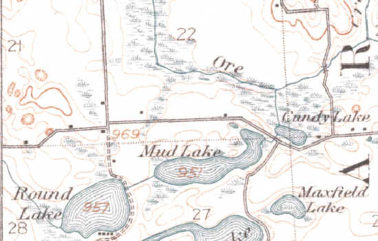
Mile 8.3 and 8.5 - While modern M-59 curves to pass north of Cundy Lake at this point, old Livingston Road proceeded more or less straight, then curved to the right around the south shore of Cundy Lake. This old stretch is now called Cundy Road. The "road on right" would thus be Bullard Road while the "small lake on right" is Cundy Lake. See the 1909 USGS topographic map of this area at right.
Mile 8.6 - The "road ... on left" is modern-day Maxfield Lake Road, while the "chain of small lakes on left" are Handy (then Mud) Lake and wetlands surrounding it. The "end of road" was where Livingston Road met modern Clark Road at a "T" intersection. Here the motorist would turn left (south), proceed a short distance, then turn right (west) again, at which point Round Lake would be to the left (south). See the 1909 USGS topographic map of this area at right.
Mile 10.3 - This "crossroads" corresponds more or less to the intersection of M-59 with Old US-23, which once led due north from this point to Hartland. When new US-23 was built, however, it cut the old road in half, with the northern portion (starting just south of Dunham Road) becoming part of Hartland Road.
![]()