| HARVEY LAKE ROAD REALIGNMENT |
|---|
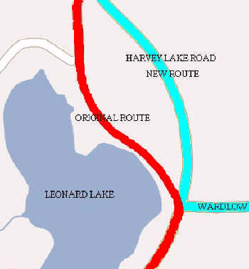
Up until the late 1960's Harvey Lake Road was likewise a rural country lane. Its narrow gravel roadbed was lined with ancient trees whose branches formed a shady canopy. With the growth of subdivisions such as Axford Acres, however, change soon came. Not only was the road widened and paved, but a significant portion was rerouted as shown on this map. The red line shows the original alignment, which turned sharply at East Wardlow Road and followed the east shore of Leonard Lake before resuming a straight northward course. The blue line shows the new road shifted to the east, creating a more gentle curve.